Flooding is a familiar foe on the Lummi Reservation

Maddy Crerar and her daughter stood at pavement’s edge, where Slater Road disappeared beneath the swollen Nooksack River. A quarter-mile of the rural road — the primary access to the coastal Lummi Indian Reservation in Washington’s Whatcom County, just south of the Canadian border — was submerged.
Instead of cars, trumpeter swans honked near the far shore.
“I am going out to Lummi Clinic,” Crerar said.
At the time, Friday morning, floodwaters had cut off two of three main access roads to the Lummi Reservation near Ferndale.
Sponsored
With Google Maps directing her into the river, Crerar said she didn’t know how she’d get to her appointment, but she was not too flustered by having to figure out a detour.
“I guess I'm just more concerned with people in the community getting the resources and help that they need right now,” she said.
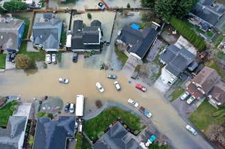
Floodwaters from the Nooksack River caused widespread damage and evacuations in Whatcom County.
As of Monday, 17,000 people had been advised or ordered to evacuate in the county, according to the Washington Military Department.
The Lummi Nation declared an emergency on Thursday. The low-lying Lummi Reservation is regularly flooded by high river flows and high tides.

“We seem to be experiencing catastrophic flooding every few years,” Lummi Indian Business Council chair Tony Hillaire said. “It's almost like we experience hundred-year floods almost every other year.”
Washington State Climatologist Guillaume Mauger said it’s unclear whether flooding in most of the Nooksack basin has been getting worse.
“Very few of the Nooksack gauges have long enough records,” he said by email.
Atmospheric rivers and the flooding they can bring are expected to get worse as human pollution keeps warming the global climate.
Warmer air can hold and unleash more moisture.
Sponsored
Communities farther up the Nooksack River seemed to bear the brunt of the latest flooding. Search and rescue teams received at least 60 calls for rescues in the towns of Everson, Nooksack, and Sumas.

“This flood is very similar to the one we experienced in 2021 and has devastated much of Sumas,” Sumas Mayor Bruce Bosch posted in a Thursday update. “I am deeply sorry that our community is facing this hardship again, but I am relieved that most residents evacuated when advised.”
Sumas residents were allowed to return to their homes, but not pour anything down their sinks or flush their toilets, on Saturday.

Hillaire said Friday the tribe was monitoring a levee near Slater Road. In 2021, that levee broke. All access roads to the Lummi Reservation were cut off from the outside world by floodwaters.
Sponsored
“We became a complete island,” Hillaire said.
In 2021, the medical clinic ended up boating its staffers in from the Port of Bellingham so they could keep the clinic open.
RELATED: Lummi tribe improvises as flooding turns its reservation into an island
On Friday, retiree John Doesburg walked past the road-closure barricade to see the floodwaters. He said he walks along a riverfront trail there five days a week. A three-mile trail hugs the eastern bank of the Nooksack River through state parks and hunting areas.
“It's my favorite trail,” he said. “It's just a beautiful area, but right now it's just inundated with water.”
Sponsored
Flat areas near streams and rivers are called floodplains, and flooding there can help absorb a river’s overflow before it does much harm to more built-up areas.
“We do need to have areas where water can overflow without damaging homes and hurting people,” Doesburg said.
Hillaire said the Lummi Nation has been lobbying for state and federal funding to build an elevated, flood-proof Slater Road over the Nooksack River floodplain.
“The road itself is owned by the county, but we need to figure out a way to work together to fix it so that we don't have to deal with this every couple of years,” Hillaire said.
On Sunday, Lummi officials said the Nooksack floodwaters had flowed over the top of the levee south of Slater Road, but that the levee was undamaged. They reopened the tribe’s main access road — at least until the next time the Nooksack River overflows its banks.
Sponsored
On Tuesday, the National Weather Service issued a flood watch for Western Washington through Thursday afternoon, warning of an increased risk of landslides due to heavily saturated soils.
-
John Ryan

Environment Reporter
John Ryan joined KUOW as its first full-time investigative reporter in 2009 and became its environment reporter in 2018. He focuses on climate change, energy, and the ecosystems of the Puget Sound region.
More stories from John Ryan »