The weather is not finished with Western WA: Lowland snow, freezing temps expected
UPDATE: The last time Western Washington faced a blizzard warning was 2012, according to the National Weather Service in Seattle. Now, 2024 has opened with a blizzard that announced itself with thick mountain snow, treacherous roads, strong winds, high surf and coastal flooding, and heavy rain across the lowlands.
The intense weather is not finished with Western Washington as freezing temperatures are expected to come next. Meteorologist Kirby Cook with the National Weather Service in Seattle calls this a "mixed bag" of weather stretching across the region.
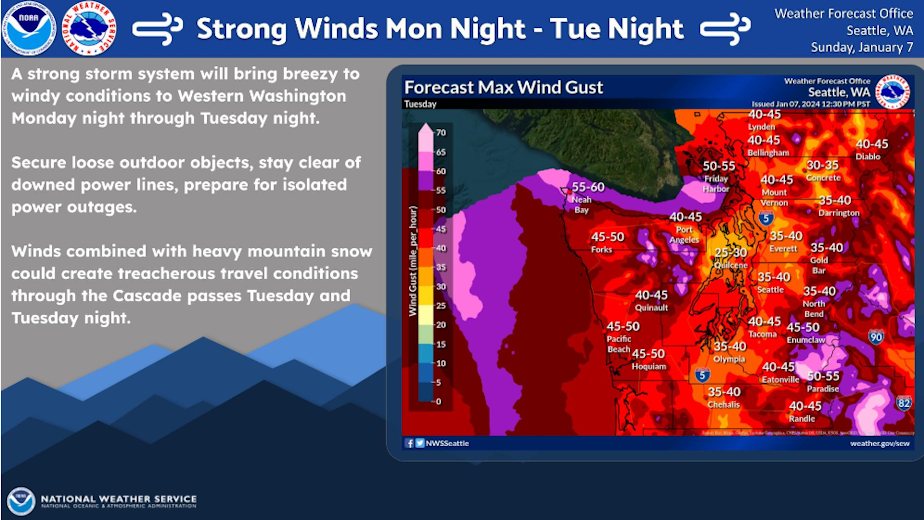
"We're looking at a return to winter weather this week," Cook said, noting that strong winds will continue with gusts up to 65 mph, in the Strait of Juan de Fuca through the Whidbey Island area into Wednesday. Rain will continue with some thunderstorms.
Then, Western Washington temperatures will start to chill out.
"Depending on exactly where you are, anywhere from a 50-70% chance for at least an inch of snow in the lowland areas of Western Washington, which is pretty significant," Cook said.
Looking ahead, Cook said Western Washington can expect:
- Some potential for snow in the lowland areas late Tuesday and early Wednesday morning, most likely in the south Puget Sound area (Olympia and along the I-5 corridor to Portland). Potentially 1-2 inches of snow.
- Increased potential for lowland snow Thursday through Saturday. High temperatures in the upper 20 degrees are expected Friday and Saturday. Overnight temps could dip into the teens. Cook says such conditions are unusual for the area, and that any precipitation that falls will come as snow.
- "It does look like there is a chance for some lowland snow early (Wednesday) morning ... mostly gonna be south of Olympia ... some of the higher hilltops in the Seattle area could see some snow. I wouldn't expect any significant accumulation with that."
- "Pretty significant snow" could hit the northeast corner of the Olympic Peninsula.
- Weekend will transition to warmer temps, with means a potential for freezing rain.
"It's really looking like as we transition out of the windy conditions in the next 24 hours or so we're going to move into a much cooler classic a winter weather pattern for the Northwest, certainly in Western Washington really through the weekend," Cook said.
The blizzard warning for the mountains is still in effect until Wednesday morning. Cook notes that's when the winds will calm down, but the snow is expected to continue. Elevated avalanche conditions are a concern.
The National Weather Service in Seattle reported late Monday night that wind gusts ranging up to 50-60 mph were moving through Western Washington, along with "enhanced showers." Tuesday morning, WSDOT asked drivers to consider delaying trips over the mountain passes, such as Snoqualmie Pass, due to heavy snowfall and poor visibility. Otherwise, drivers are asked to be prepared with "appropriate traction tires." Road conditions have already caused crashes on I-5 over Snoqualmie Pass.
ORIGINAL REPORT
Get your candles ready for power outages, and expect roadways to snarl. A blizzard is coming to Western Washington this week.
A blizzard warning has been issued for the Olympic Mountains and the Cascade Mountains in Western Washington. But the snow in the mountains is not the only weather event slated for the region that residents should plan around.
"A significant storm system will bring heavy snow and major impacts to portions of the Pacific Northwest beginning today. Blizzard conditions are likely in some of the higher terrain where multiple feet of snow may accumulate," the National Weather Service's Weather Prediction Center stated Monday morning.
The blizzard warning is active through Wednesday morning. The Center forecasts "several feet" of fresh snow in the Cascade Mountains over Monday and Tuesday evening, from "back-to-back storms."
Expect mountain passes to be affected. The National Weather Service in Seattle reports that the last time Western Washington had a blizzard warning was 2012.
Sponsored
Snow levels are estimated to fall to as low as 1,500 feet Tuesday night, but communities in lower elevations should be prepared for heavy rain that could cause flooding and increase the likelihood of landslides. Strong winds are also expected to blow through the region.
The National Weather Service issued a special weather statement for areas including Bellingham, Seattle, Olympia, the Kitsap Peninsula, and along the I-5 corridor down to Portland. According to the NWS's statement:
"Rainfall over the past week has increased soil moisture to moderate levels across western Washington. Heavy rainfall of one to two inches in the lowlands and two to five inches in the mountains is expected over the next two days. This amount of rain will put extra pressure on soil instability, leading to an increased but marginal threat of landslides. Steep terrain, coastal bluffs, and slope cuts like for roadways are some of the most landslide prone areas. Areas above 6000 feet in elevation will see mostly snow and not be affected."
Sponsored
As of Monday's forecast, temperatures in Seattle could dip below freezing later in the week, which could mean icy roads over the weekend.
On Jan. 3, KUOW reported about the Northwest's record warm December and extremely low snowpack. At that time, much of Western Washington was recording less than 50% of normal snowpack. As of Jan. 8, the U.S. Department of Agriculture reports that new snow had improved conditions, with many regions now reporting between 50-69% normal snowpack. That is still below the level of snowpack expected for this time of year.
-
Dyer Oxley

Online Editor/Producer
Dyer Oxley joined KUOW as an Online Editor/Producer in 2020, handling day-to-day upkeep of the station’s website while providing editorial oversight. He also helms KUOW’s Today So Far newsletter, an insightful daily roundup of what KUOW is reporting ... so far.
More stories from Dyer Oxley » -
Diana Opong

Diana Opong was formerly a general assignment reporter at KUOW.
More stories from Diana Opong »