Snohomish planners reflect on flood safety in wake of Texas tragedy
The high death toll from the July 4 flood in Kerr County, Texas, has prompted questions about flood preparation across the country. Western Washington is one of the most flood-prone regions in the United States, according to the National Weather Service.
To find out about preparations in Snohomish County, KUOW’s Paige Browning spoke to Emergency Management Director Lucia Schmit and Surface Water Management Director Gregg Farris.
This interview has been edited for clarity.
Paige Browning: I imagine the loss and devastation we've seen in Texas over the last several days is on your minds. Your job is to prepare for such events. What are your reflections in these past few days?
Lucia Schmit: To start off, as a parent who currently has two kids at sleep-away camp, it's just unimaginable what those families in Texas are going through. My heart really goes out to the survivors, to the first responders that are sifting through all that mess. It is a tragedy. We do in emergency management try to always learn from tragedies, wherever they're happening. I think one of the clear messages coming through now is just the challenge of forecasting in our changing climate. Many of our forecasting models are built off old climate data. The more science and analysis and continual assessment we can do of our systems and of our changing climate and its impact on our rivers and on our weather systems, the better off we’ll be.
Gregg Farris: As I've watched what’s happened on the news, the loss of life is just heartbreaking and unimaginable. We do experience a lot of flooding here in Snohomish County. Thankfully, we're not susceptible to the same kind of flash flooding that they have in that part of the country. Our rivers generally rise more gradually here. They can rise quickly, but not at the rates that they experience in the flash flood parts of our country.
How would you describe the state of flood preparation in Snohomish County. What's working, and what may be missing?
Sponsored
Schmit: I think one thing that's working really well is all of the work that is happening in Snohomish County, whether it's through our surface water management folks or through our planning and development services, to help ensure that we're not building critical infrastructure in the floodplain.
On the response side, we're doing a lot of work on evacuation planning. We're currently finalizing an evacuation and shelter-in-place annex, so that we better understand roles and responsibilities if we do face a situation where we need to tell people to get out quickly. Part of that has been coordinating with neighboring jurisdictions on "Ready, Set, Go" messaging, so that our community understands the messages they might receive, what they mean, and what to do at the various stages.
And then we are constantly reevaluating after every flood event. After every significant weather event we meet with all of our partners and talk about what we can do better, and then develop plans that will help us improve and respond better in the future.
Farris: As far as flood preparedness, we coordinate closely with our local flood districts. We also have a flood warning system in place, which is essentially tracking river levels and flood levels at gauges along these rivers at key points where people look at and track how high the river is getting. As Lucia mentioned, we have good regulations in Snohomish County to try to keep new development and structures out of our flood plains, so that helps limit damage during flood events.
What was the most damaging recent flood in Snohomish County?
Sponsored
Farris: The biggest recent flood we've had happened a year and a half ago in December of 2023 on the Stillaguamish River. It was our largest flood of record. Our river gauges got higher than they've ever been recorded in the decades that we've had those gauges in place. Thankfully, the damage that occurred was not significant. Some local farmers experienced flooding and damage to outbuildings, but it wasn't a devastating extent of flooding, even though it was the largest flood of record.
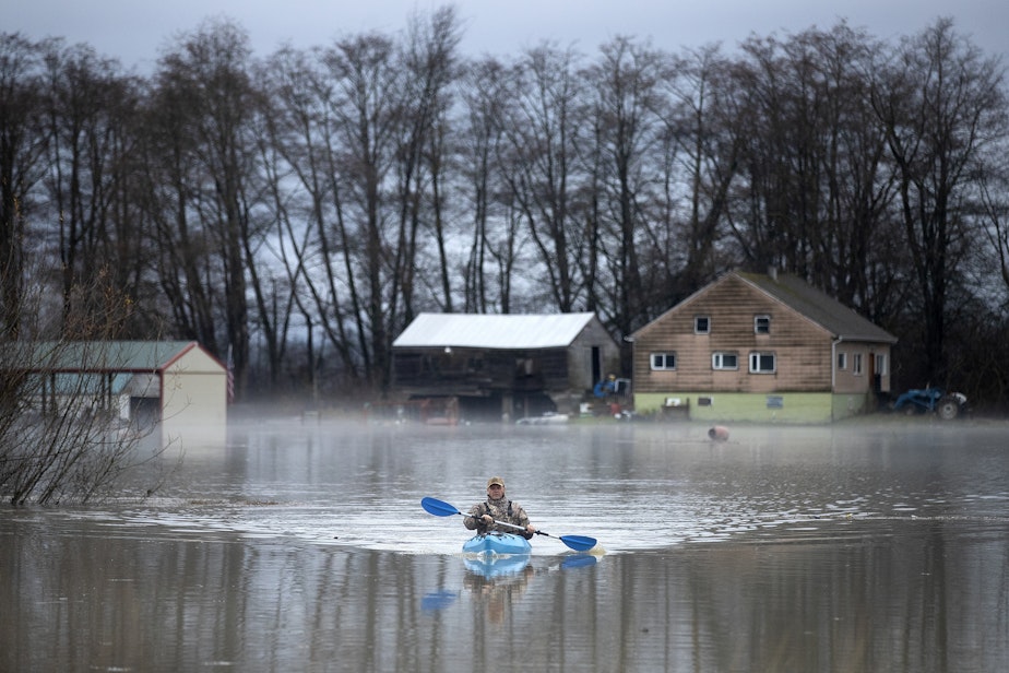
I'm recalling photos from that time on the Stillaguamish of people kayaking near homes. There were no deaths in that incident. Can you point to anything that changed in its wake?
Schmit: One of the things we learned from that is that the Stillaguamish, the river itself, has changed, partially because we're doing things to make it a more fish-friendly habitat. Less dredging is happening. But one of the things that led to on our side was looking at different ways we can supplement those river gauges that Gregg mentioned. So, looking at who owns the rain gauges uphill where the precipitation was falling, so that we can monitor rainfall more directly and not wait for it to hit the rivers.
We look at who we have in our volunteer banks near the rivers, who can go out and just take a look and let us know what they're seeing. We held meetings with community leaders up and down the Stillaguamish basin to try and gather some of their institutional knowledge about where are the places that we should watch for flooding to know whether or not we should be concerned.
Are you getting the support you need to be prepared for floods on the state and federal level?
Sponsored
Schmit: I am very concerned about funding cuts that we're seeing coming down from the federal government. At the Department of Emergency Management, we have about a third of our core staff that are funded through pass-through grants from the federal government. We are very concerned about talk of funding cuts.
We had about a $500,000 grant through the Building Resilient Infrastructure and Communities (BRIC) program that was specifically to help us work on mitigation planning with the cities and towns. That means working with the cities and towns to identify places that they know of that might be at risk, and to develop plans and strategies to reduce that risk. That grant got pulled back when the BRIC grant was canceled.
And then, I think critically, we rely on the National Weather Service for our forecasting. Any cuts to their staffing or their capabilities have us very concerned. Looking at this Texas example in particular, I think this is a prime example of why the climate science aspect of the National Oceanic and Atmospheric Administration was critical science to be conducting. Our weather patterns are changing, and the more we can understand them the better off we'll be.
Farris: I think Lucia captured that. We do rely on the National Weather Service for forecasting. They run models that take the rain predictions and translate that into how high the rivers might get. And that's a vital, valuable service, so we would definitely want to see that continue.
Listen to the interview by clicking the play button above.
Sponsored
Paige's Full Conversation With Lucia And Gregg
-
Paige Browning

Newscaster
Paige hosts midday newscasts and monitors news of significance to the Puget Sound region. She hopped over Washington’s mountains to join KUOW, after hosting news and reporting at Spokane Public Radio since 2011. She began her start in radio while a journalism student at University of Montana, by sharing stories with KUFM. Paige was raised in the mountains and rivers around Spokane. In her spare time she cheers on the Mariners in the summer, and hopes for snow in the winter.
More stories from Paige Browning » -
John O'Brien

Senior Producer, All Things Considered
John O’Brien is KUOW's All Things Considered Senior Producer. He spends his days setting up interviews with newsmakers on subjects from politics and public health to arts and culture. John learned to make radio starting in 2006 as an intern on KUOW’s The Conversation with Ross Reynolds.
More stories from John O'Brien »


